Bus boost to revolutionise public transport
Doubling high frequency buses and connecting suburbs directly.
Getting around most of Brisbane without a car is slow, frustrating and sometimes impossible. If you don’t live near a train station or a decent bus route, public transport means long wait times, and buses that arrive late or never at all. Even high frequency services routinely get stuck in peak hour traffic.
Right now public transport isn’t a real option for so many people. It’s no wonder so many Brisbane residents still choose to drive.
In the last 10 years, the LNP Council has created just one new frequent bus service (in the Gabba Ward), and only because of Greens pressure. Over their 20 years in power, they’ve wasted billions on road widening and toll road projects that only make traffic worse.
The LNP and Labor don’t have a serious vision for fixing public transport anytime soon.
The Greens want every Brisbane resident to have a frequent, reliable bus. We want a bus network that gives everyone the freedom to leave their cars at home.
Better public transport helps everyone. It takes cars off the road and makes our streets quieter and safer. It cuts climate pollution and revitalises local shopping strips.
A Greens-led Brisbane City Council would:
- Create 15 new high frequency bus routes, doubling the number of high frequency services to link suburbs directly without needing to go through the CBD.
- Upgrade 10 existing bus routes with frequency upgrades or extensions.
- Let buses skip traffic jams by creating 13 bus priority corridors on key arterial roads which already carry frequent buses.
A real network: get anywhere by bus
The Greens’ plan would more than double the number of high frequency bus routes in Brisbane.
Our plan would create a strong, interconnected network, meaning hundreds of thousands of people will be free to get around without the hassle of driving.
Brisbane would have a total of 43 high frequency routes, up from a total of 21 today, allowing residents to get nearly anywhere by bus.
The Greens would create 15 new high-frequency routes, and 10 upgraded high frequency routes, expanding the high-frequency network by 395 kilometres, an increase of more than 100% .
This map shows the Greens’ plan for a Brissie Bus Boost, including new routes, upgraded routes plus existing high frequency bus and train corridors.
The Brissie Bus Boost could be implemented very quickly, within a year or two. It involves very minimal construction and no “mega projects” which are prone to cost blowouts and delays.
Increasing high frequency bus routes would be fast, cheap and simple, but would still dramatically improve public transport for many thousands of residents.
The Brisbane City Council currently operates Brisbane’s bus services, largely funded by the State government. Council also works with the State government to decide on the routes and timetables that it operates.
In the last 10 years, the LNP has created just one new frequent bus service on a trial basis - the 86 Kurilpa Free Loop - which only happened thanks to years of pressure from the Greens. They have also adopted parts of our plan for a new CityGlider to connect thousands of new residents in Hamilton and Woolloongabba, now called the Gold CityGlider.
We can’t wait another 10 years. The Brissie Bus Boost takes the next step and drastically improves our bus network.
New connections between suburbs
15 new high frequency routes
We want to make it practical for more people to get by without needing to use their cars.
If public transport was a real option, thousands of residents could forget about the stress and hassle of parking, petrol prices and traffic jams.
The Greens would create 15 new high frequency routes, to link suburbs directly without needing to go through the CBD:
- B1: West End to Bulimba
- B2: Annerley to Hamilton
- B3: Milton to Teneriffe
- B4: Yeronga to Coorparoo
- B5: Fig Tree Pocket - Indooroopilly - Long Pocket
- B6: Enoggera to Indooroopilly
- B7: Enoggera to Hendra/DFO
- B8: Bulimba to Corinda
- B9: The Gap to Northgate
- B10: Chapel Hill to Capalaba
- B11: Indooroopilly to Pallara
- B12: Hamilton to Upper Mt Gravatt (Garden City)
- B13: Riverhills to Upper Mt Gravatt (Garden City)
- B14: Eatons Hill to Banyo
- B15: Wacol to Springwood
These 15 services are described in detail towards the bottom of the page, and also shown on this map.
Right now, getting between suburbs - even over short distances - can be tricky. The current bus network pushes every single high-frequency route through the inner-city King George Square, Queen Street, Cultural Centre, or Woolloongabba bus stations. These stations are important, but many of us need to commute directly across suburbs as well.
The 15 new high-frequency routes would serve existing bus interchanges at major shopping centres, suburban main streets, schools, hospitals, universities and train stations instead of the CBD.
The new routes would connect existing high-frequency services, especially train lines and busways, making it easy to change services without ever having to wait more than 10 or 15 minutes for a connection.
By creating new inter-suburban routes, buses will become a real option for thousands of people who just need to get a few suburbs over for work, shopping or to see friends. Almost 400km of major road corridor will get a high-frequency “turn up and go”' bus service for the very first time.
Upgrading 10 existing routes
Many existing routes are in dire need of better service frequency and operating hours. In theory, much of Brisbane already has bus services to the CBD, but they may only run hourly, or not at all on weekends.
The Greens would upgrade 10 existing routes, including
- Upgrading seven routes to high-frequency: the 175, 192, 220, 235, 380, 390 and 470.
- Extending four routes to connect underserved suburbs including the 100, 196, 390 and 444.
These services are described in detail below, and shown on this map. By improving existing services and providing bus-priority corridors on key roads, we want these existing routes to become far more convenient.
Bus and transit lanes
If buses keep getting stuck in general traffic, taking the bus will never be an attractive option for many people who currently drive.
We would create dedicated bus lanes, T2 or T3 transit lanes on key corridors across Brisbane so that buses can keep moving thousands of people quickly, even during peak hour.
The Greens would create 13 bus priority or transit corridors on key arterial roads which already carry frequent buses, to let buses skip traffic jams:
- On the northside: (1) Kelvin Grove Road/Enoggera Road and (2) Lutwyche Road/Gympie Road.
- On the west side: (3) the Centenary Motorway, (4) a new Inner West Transitway via Sir Fred Schonell Dr and the UQ campus, (5) Coronation Drive and (6) Moggill Road.
- On the southside: (7) Old Cleveland Road, (8) Ipswich Road/Main Street, (9) Logan Road, (10) Mains Road (11) Stanley Street and Vulture Street, (12) Montague Road and (13) Lytton Road/Wynnum Road.
Bus priority would generally be T2 lanes on 4-lane roads and dedicated bus lanes on 6-lane roads, with some adjustments based on local conditions.
Except for isolated cases, bus priority corridors do not require widening roads, demolishing homes or expensive, disruptive construction. As described in detail below, most road corridors are wide enough to accommodate bus lanes or T2/T3 lanes by reallocating space away from street parking or general traffic lanes.
The biggest success story in Brisbane’s bus network is the South East Busway, which carries more people in just two lanes than the adjacent Pacific Motorway (which has 6 lanes).
Bus priority allows Council to run more frequent services with the same amount of funding, because buses aren’t wasting time waiting in traffic. Efficiencies from bus lanes and T2/T3 lanes will offset some of the cost of new services.
Many of the corridors where we are proposing bus priority are already slated for bus priority in the 2021 State government SEQ Regional Transport Plan.
Bus lanes actually grow the capacity of a road: a general traffic lane can move between 1000 to 2800 people per hour, but a dedicated bus lane can grow that to between 4000 and 8000 people per hour.
What is “high frequency”?
Brisbane currently has 21 “high frequency” bus services including the CityGliders and BUZ services. These are services where you can “turn up and go” without checking a timetable. This number would jump to 43 with the Brissie Bus Boost.
The Greens’ 15 new routes and 10 upgraded routes would match the existing BUZ services, with buses between 6am and 11:30pm, running every 10 minutes or better during peak hours and every 15 minutes or better for the rest of the day.
The existing high-frequency services already carry a huge proportion of all public transport passengers in Brisbane. Based on published Translink data, high frequency services carried 51% of all passengers. High frequency services mean residents can plan their school drop-off run, their commute to work or an evening out, knowing that a bus will be coming soon.
New cross-city connections and future Green Bridges
The Brissie Bus Boost creates one new bus connection and leaves open the possibility of two new Green Bridges, supported by high frequency bus services.
A new Inner West Transitway including a bus link across UQ’s St Lucia campus and a bus priority corridor on Sir Fred Schonell Dr would create the possibility for the new B10 Indooroopilly to Capalaba route, or similar east-west links. State Greens MP Michael Berkman has been campaigning for this new link since 2022. This new connection would be a game-changing improvement for both the inner-west and inner-south of Brisbane.
This plan also leaves open the possibility of two new cross-river bus connections by creating high frequency services:
- Possible connection to Bellbowrie: The proposed B13 Riverhills to Westfield Mt Gravatt service could easily be extended to Bellbowrie if a bus, cycling and walking bridge is built in the future.
- Possible connection to Bulimba: The proposed B1 West End to Bulimba and B8 Bulimba to Corinda services could easily be extended to Newstead/Teneriffe if a bus, walking and cycling bridge is built in the future.
Green Bridges are outside the scope of this particular campaign initiative, but the Greens believe the highest priority Green Bridge project is the Toowong to West End bridge for walking and cycling. We support feasibility analyses and public consultations for Green Bridges at Bellbowrie/Moggill to Centenary (walking, cycling and buses) and Bulimba/Hawthorne to Newstead/Teneriffe (walking, cycling, with buses subject to feasibility assessment and community consultation).
What about Brisbane Metro?
Council is currently delivering a Bus Rapid Transit project on the State-owned busway called Brisbane Metro, due to commence in late 2024. Our proposal complements the improvements offered by the Metro.
Doubling high frequency services combined with the Greens’ ambitious plans for 13 bus priority corridors will deliver “turn up and go” services which don’t get stuck in traffic. Our plan would deliver similar benefits for commuters as the Brisbane Metro at a fraction of the cost.
The Brissie Bus Boost could be delivered with conventional electric buses, including biarticulated buses with large passenger capacity.
Brissie built electric buses
The Greens strongly support local bus manufacturing. We would aim to make sure all new buses are electric or zero-emissions, working with the State Government to make sure funding is available to support this transition. We would adopt a medium term target to reach a 100% zero emissions, locally built bus fleet as fast as possible, aiming for 2030.
Electric buses are clean, quiet and cheaper to run. The transition to zero emissions buses could include retrofitting Council’s existing gas-powered bus fleet to electric.
A growing network
Our plan for the Brissie Bus Boost is designed to raise the level of ambition for fixing public transport and broaden the parameters of discussion. So these are not the only changes we would be likely to make to Brisbane’s bus network over the next four years.
Where strong evidence and community desire emerges, other routes or service improvements could be added in future.
Funding for the Brissie Bus Boost
Public transport in Queensland is largely funded by the State government, which also collects all fare revenue.
Brisbane City Council currently operates Brisbane’s bus services under a contract with the State government. Council has significant influence over the routes and timetables that it operates.
The Greens in Brisbane City Council would put forward the Brissie Bus Boost for funding to the State government, alongside a significant funding increase from Council itself.
We would propose an agreement with the State government with more funding for public transport and less State government spending on wasteful road widening projects.
The total cost for the additional bus services in the Brissie Bus Boost would be $169 million per year including:
- $142 million for the 15 new high frequency bus services
- $27 million for the 10 upgraded bus services.
These costs are based on published per/km running costs for the Maroon CityGlider.
The Brissie Bus Boost would be a 36% funding increase for buses in Brisbane.
The current total cost of operating the Brisbane bus network is $465 million per year, with 77% being provided by the state government, and the remaining 23% coming from the City Council.
Beyond the joint funding agreement with the State government, Council would consider how to further consolidate any existing services which might be duplicated or redundant as a result of the 15 new and 10 upgraded high frequency routes. Consolidating services would make best use of the available drivers, vehicles and funding.
|
Item |
Funding/year |
|
Existing bus network funding (including State + Council funding) |
$465 million |
|
Brissie Bus Boost: additional funding |
$169 million |
By contrast, just three wasteful road widening projects have cost Council almost $1 billion:
- Adding two extra lanes to just 650 metres of Lytton Road cost Council $115 million,
- Widening just 3km of Kingsford Smith Drive cost $635 million.
- The wasteful and disruptive Moggill Rd / Coonan St “upgrade” has blown out again to $234 million.
Since the LNP came to power in Brisbane City Council in 2004, the public and private sectors have spent $10 billion building toll road tunnels. Despite that, leading transport experts have found those tunnels now have “no congestion-busting benefit” because they have simply entrenched car-dependency while starving public transport of funding.
The State government spends even more on wasteful road-widening projects. In South East Queensland, they are planning to spend $8.7 billion on road and freeway projects over the coming years.
Both the LNP Council and the Labor State government are set to repeat the same mistakes. Both are supporting an $8 billion publicly-funded toll road tunnel under Gympie Rd from Kedron to Carseldine which would be the single most expensive road project in Queensland’s history.
Funding for the 13 new bus priority corridors would be reallocated from within Council’s large roads budget, alongside additional funding from the State government’s Passenger Transport Infrastructure Investment Program.
Free public transport
The Greens strongly support free public transport as a powerful form of climate action, cost of living relief and transport policy to bust congestion.
Fares in SEQ are some of the most expensive in the world. Right now, especially for short trips, fares can be 8 times more expensive than the cost of fuel. That is not sustainable, especially in a cost of living and climate crisis.
The State government has the resources to fund free public transport for every Queenslander, and the Greens in Brisbane City Council would continue to make the case for that historic reform.
15 new high frequency bus routes: Detailed descriptions
Below are detailed descriptions of each of the 15 new high frequency bus routes. The routes are shown on this map in the layer “15 New High Frequency Routes”, in dark green alongside the rest of the Greens’ plan for the Brissie Bus Boost. The map also includes existing high frequency services (trains and buses).
|
B1: West End to Bulimba (Previously the Greens’ proposed Green CityGlider) This route serves as an east-west link connecting the high density residential precincts in West End and Woolloongabba with major schools, hospitals and employment precincts and the Bulimba high street. The Greens have been campaigning for this route (also called the Green CityGlider) for years. Key details are online here. It begins outside Woolworths at Montague Markets in West End, taking Vulture St to Woolloongabba and East Brisbane, continuing to Norman Park and Bulimba via Wynnum Rd. After feedback from local residents, the route through Bulimba was updated to take Riding Road instead of Hawthorne Road. It continues along Oxford Street to the Bulimba ferry terminal. This route could easily be extended across the river to Newstead/Teneriffe if a bus, walking and cycling bridge is built in the future. |
|
B2: Annerley to Hamilton (the Greens’ proposed Orange CityGlider) This route serves as a vital north-south connection which avoids the CBD, connecting rapidly densifying Woolloongabba to the Valley, Newstead and Hamilton. It would bring high-frequency public transport to Kangaroo Point and the new Northshore Hamilton precinct for the first time ever. It begins at Cracknell Rd in Annerley, following Ipswich Rd (which would be upgraded for bus priority) and travels to Woolloongabba busway/Cross River Rail stations through Kangaroo Point and across the Story Bridge. It takes Wickham St / Ann St and Kingsford Smith Drive (which will also receive bus priority upgrades), finishing at the new high density Northshore Hamilton precinct. The Greens previously proposed this route as the Orange CityGlider, and it is an alternative to the LNP’s proposed Gold CityGlider.  |
|
B3: Milton to Teneriffe This route serves an east-west link for the inner-northeast to inner-northwest of the city, connecting Teneriffe to Park Rd in Milton. From east to west, this route begins at Teneriffe ferry terminal, heading along Skyring Terrace through Newstead and Bowen Hills, near Bowen Hills station. It connects to the Royal Brisbane Women’s Hospital, before crossing Bowen Bridge Road towards Exhibition station, and turning west down Herston Road. It continues by the Herston bus station, UQ Herston Campus, Victoria Park / Barrambin, and QUT Kelvin Grove, before crossing Kelvin Grove Road at the 345 BUZ stops to turn onto Windsor Road. It continues through Red Hill, before connecting the newly upgraded 380 BUZ on Musgrave Road, and turning down Balmain Terrace into Paddington. It then travels along Given Terrace, connecting the 61 Maroon Cityglider and 385 BUZ, before taking Fernberg Road. It continues onto Baroona Road into Milton, before terminating on Park Road. This route connects several growing neighbourhoods, transport nodes, education centres and high streets, and a major hospital, across the inner-north, all without travelling into the CBD. 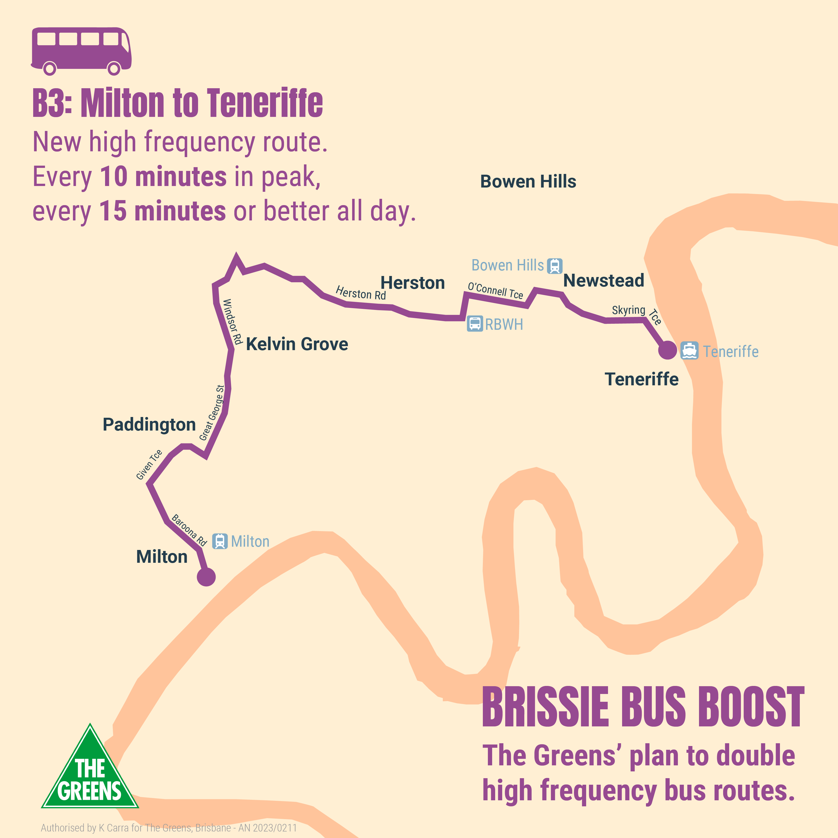 |
|
B4: Yeronga to Coorparoo This route connects the inner south and inner east of the city, linking Yeronga to Coorparoo. Southwest to northeast, it begins in Yeronga, travelling from the emerging medium density precinct around Hyde Rd down the spine of the suburb onto Fairfield Road, connecting into Fairfield train station and Annerley high street, then connecting across to the Greenslopes busway station and Greenslopes via Ridge Street, continuing through Chatsworth Road and Cavendish Road into Coorparoo. It then connects the nodes of Coorparoo Square, Coorparoo train station, and Coorparoo Secondary College. This route covers population centres with no frequent service, and provides inter-suburban connection to several transport, commercial, and education centres while avoiding the inner ring bus stations. |
|
B5: Fig Tree Pocket - Indooroopilly - Long Pocket (AKA "The Pocket Rocket") This route serves two drastically underserved west side suburbs, linking Fig Tree Pocket to Long Pocket via Indooroopilly. it begins at Long Pocket near the new medium-density retirement complex and townhouse developments at Meiers Rd, connecting to ISHS, St Peters, Brigidine, Holy Family schools, Indooroopilly train station, Indooroopilly shopping centre bus station, Ambrose Treacy College, several schools in Fig Tree Pocket, and finally Biambi Yumba park on Fig Tree Pocket Road. Greens MP for Maiwar Michael Berkman has been calling for better buses in both Fig Tree Pocket and Long Pocket for many years. |
|
B6: Enoggera to Indooroopilly This route serves a north-south link for the inner-west and northwest of the city, linking Indooroopilly to Enoggera. South to north, it begins at Indooroopilly train station, before connecting Indooroopilly shopping centre bus station, and heading through Taringa to Toowong train station and shopping centre. It then travels across Toowong to take Metroad 5 into Bardon, diverting along Boundary and Simpsons Road before rejoining Metroad 5 north to the Bardon shops and into Ashgrove. It diverts to connect Ashgrove shopping street before turning north again on Metroad 5 through Ashgrove and Enoggera, terminating at Enoggera train station. This route provides frequent service along corridors of Toowong, Bardon, Ashgrove and Enoggera that currently have no services, and provides strong connectivity between key commercial, population and transport centres without travelling into the city. Greens MP for Maiwar Michael Berkman has been campaigning for a high frequency connection between Bardon and Toowong since 2019, and this service is a key part of the Greens’ plan to fix MetRoad 5. |
|
B7: Enoggera to Hendra/DFO This route services an east-west link for the northside, linking Enoggera to Hendra and Brisbane DFO. East to West, it begins at the Enoggera train station, before heading north to Everton Park shopping centre, and turning East along Stafford Road to connect Stafford City shopping centre, Gordon Park, near Padua College, St Anthony’s, Mt Alvernia College, Kedron SHS. It connects with the 333 and 340 BUZ services on Gympie Rd and then continues along Park Road and Rose Street to connect northern Wooloowin and Eagle Junction Station and local schools, before connecting other bus services on Sandgate Road in Clayfield. It continues east across Hendra and at Nudgee Road it turns north, finally terminating at the DFO. This route provides frequent service to areas of northern Brisbane that have very poor public transport, and allows for inter-suburban connection between population, commercial, education and transport centres without travelling towards the city. |
|
B8: Bulimba to Corinda This route serves as a very significant northeast to southwest link for the whole southside linking Bulimba to Corinda train station, and connecting with every train line, busway and high frequency bus service along the way. From Bulimba, this service connects the ferry terminal and Oxford St shopping strip in Bulimba to Balmoral, the Morningside train station, Seven Hills, Camp Hill at Old Cleveland Rd, Holland Park at Logan Rd, Holland Park West busway station, Tarragindi at the Wellers Hill shopping strip, Moorooka high street, Moorooka train station, Rocklea Markets and Corinda train station. This service links several underserved suburbs with transport nodes, and provides an option between suburbs that avoids travelling into the inner ring stations. Note that once Sherwood train station is upgraded for disability access this service would terminate there instead of Corinda. |
|
B9: The Gap to Northgate This route creates new east-west linkage across the northside, from The Gap to Northgate, including a connection with the Ferny Grove train line. It begins at The Gap shopping centre on Waterworks Road, before turning north along Settlement Road to connect the Great Western Super Centre at Keperra, connecting with Grovely station and TAFE Campus, via Dawson Pde, and on to Arana Hills Plaza. It then turns onto Pimelea St/South Pine Rd, connecting Everton Hills shopping centre, and turning down Hamilton Rd to connect Mcdowall, Stafford Heights, Prince Charles Hospital, Chermside shopping centre, Wavell Heights, before turning south to connect Nundah and Nundah Village, passing by the train station, before turning north along Sandgate and Northgate Road to connect Northgate, terminating at Northgate train station. This route provides frequent service to areas of north and northwest Brisbane with very little public transport, and allows for inter-suburban connection between housing and major transport, commercial, education and healthcare nodes without travelling towards the city. It also creates the first ever high frequency connection between The Gap and the Ferny Grove train line. |
|
B10: Chapel Hill to Capalaba This city-shaping route serves a key east-west link, connecting Chapel Hill and Indooroopilly shopping centre and train station to the Capalaba commercial district via the southside. West to east, this service connects the base of Mt Coot-tha in Chapel Hill to the Indooroopilly shopping centre and train station, then services the fast-growing medium-density precinct on Swann Rd, continuing to St Lucia and UQ. It travels across the Greens’ proposed new UQ bus link (part of the Inner West Transitway), to the Eleanor Schonell bridge. It then connects Park Road Station, PA Hospital, Buranda Station and Stones Corner via the busway, then Coorparoo Square, Camp Hill, Carina, Carindale shopping centre, Sleeman Sports Complex and Capalaba shopping centre via Old Cleveland Road. Old Cleveland Rd would receive bus priority upgrades under the Brissie Bus Boost. This route creates a major new cross-city linkage without entering the CBD. It could be delivered via an extension on both ends of the current 209 bus. The Chapel Hill - Indooroopilly - UQ route is nearly the same as the 427 and 428 buses, and similar to the 432, so some consolidation of those routes might be possible to save money and create a more predictable, frequent service. This route connects several growing population, commercial, transport and education centres. To make this happen, and make the whole transport network more effective, new infrastructure needs to be agreed to by the University of Queensland, and BCC would need to negotiate with Redland City Council to terminate at Capalaba. Michael Berkman has been campaigning for the UQ bus link, which is described further below (see Inner West Transitway). |
|
B11: Indooroopilly to Pallara This route serves a north-south link for the inner-west to southwest of the city, connecting Pallara to Indooroopilly. From south to north, this route begins at Pallara State School, heading west along Wadeville Street through Pallara and Heathwood onto Forest Lake Boulevard, connecting Forest Lake and Forest Lake shopping centre, and Richlands train station. It then follows Archerfield Road to connect Richlands, and then Harcourt Road and Railway Parade to connect Darra and Darra train station. It joins onto Centenary Highway northbound, connecting Mt Ommaney shopping centre, Jindalee DFO, and finally turns down Moggill Road to connect Indooroopilly shopping centre and train station. The Centenary Highway and parts of Moggill Rd would also receive bus priority upgrades in the Brissie Bus Boost. This route services many areas that do not currently have frequent service, and links suburbs with several hubs of transport and commercial activity, while feeding into the Indooroopilly node. |
|
B12: Hamilton to Upper Mt Gravatt (Garden City) This route serves a clear North-South link for the east of the city, linking Hamilton to Upper Mt Gravatt (Garden City). South to North, this route begins at the Upper Mt Gravatt (Garden City) bus station, following Newnham Road to connect Upper Mt Gravatt, before turning onto Creek Road to connect Mansfield, Carindale bus station, Carina, Cannon Hill (diverting to connect to Cannon Hill train station), and Murarrie, before crossing the Gateway Bridge to connect Hamilton, and terminate at Hamilton Northshore ferry terminal. This creates a strong north-south inter-suburban connection between commercial, transport and population centres that currently does not exist, allowing for better connection between Eastern suburbs while completely avoiding the inner ring. |
|
B13: Riverhills to Upper Mt Gravatt (Garden City) This route serves a key east-west link for the south of the city, linking Riverhills to Upper Mt Gravatt shopping centre (Garden City). West to east, this service connects Riverhills, Middle Park, Jamboree Heights, Mt Ommaney shopping centre, Darra train station, Salisbury train station, QE2 Hospital and Griffith Nathan campus, and finally Garden City. This provides a huge amount of inter-suburban connection where little currently exists, and connects several transport nodes, commercial centres and population centres while avoiding the inner ring. This service could easily be extended to the Bellbowrie shopping centre if a bus, walking and cycling bridge is built in the future. |
|
B14: Eatons Hill to Banyo This route serves an east-west link for the outer-north of the city, connecting Eatons Hill and Banyo. From west to east, it begins at the Eatons Hill shopping centre, following South Pine Road, before turning down Albany Creek Road to Albany Creek and its shopping centre, Bridgeman Downs, Aspley and its shopping centre, Robinson Road Marketplace, Zillmere, Geebung and its train station, and Virginia’s industrial park. It then turns down Sandgate Road to connect to Virginia train station, before turning down St Vincents Road to connect Virginia, Banyo and its train station, Nudgee, the Nudgee Waterhold Reserve, and finally the Australian Catholic University campus. This route provides frequent services to the outer north, which is currently very poorly served. It creates several inter-suburban connections between population centres, and transport, commercial, industrial and education hubs. To make this happen, BCC will need to negotiate with the Moreton Regional Council about the section of the route that falls into their jurisdiction. |
|
B15: Wacol to Springwood This route creates an east-west link for the outer-southside of the city, linking Wacol to Springwood. West to east, it begins at Wacol train station, heading along Progress Road, connecting Richlands station and Richlands, continuing onto Poinsettia Street into Inala and Inala Plaza to connect with the 100 BUZ and 110 service, then continuing down Inala Avenue into southern Durack, Willawong and Acacia Ridge before turning onto Beaudesert Road into Algester and connecting to Sunnybank Hills and Calamvale shopping centres along Compton Road, as well as the 130 and 140 BUZs. It continues across Stretton to Underwood, before terminating at Springwood shopping centre, at future Springwood busway station. This route provides frequent service to areas of Brisbane that have very little frequent public transport, connecting several commercial, population and transport centres with an inter-suburban connection without travelling towards the city. To make this happen, BCC will need to negotiate with the Logan City Council about the section of the route that falls into their jurisdiction. |
Ten upgrades for existing bus routes: Detailed descriptions
Below are detailed descriptions of each of the 10 upgraded bus routes. The routes are shown on this map in the layer “10 Upgrades for Existing Routes”, in purple alongside the rest of the Greens’ plan for the Brissie Bus Boost. The map also includes existing high frequency services (trains and buses).
|
Extending the 100 BUZ to Pallara The 100 is an existing high-frequency route that connects from Queen Street station, through to the Woolloongabba station, then running south along Ipswich Road to Oxley, before turning south along Blunder Road and then off main roads to connect Durack, Inala Plaza, and Forest Lake. This extension connects the almost completely unserved suburbs of Heathwood and Pallara into the 100 route. The extension will simply continue the route along Forest Lake Boulevard onto Wadeville Street, past Pallara State School and on to Ritchie Rd. |
|
Upgrading the frequency of the 175 The 175 is an existing route that connects from Fortitude Valley along Adelaide Street, then passes through the South-East Busway to Woolloongabba bus station before following Logan Road all the way to Westfield Mt Gravatt. This frequency upgrade will greatly improve service along the Logan Road corridor through Greenslopes, Holland Park, and Mt Gravatt. The 175 is due for a modest upgrade under the Council’s proposed Bus Network Review in connection with the Brisbane Metro. The Greens’ plan would make sure it is upgraded to a BUZ. |
|
Upgrading the frequency of the 192 The 192 is an existing very low frequency route that connects from the CBD along Adelaide Street, through Melbourne Street to Mollison Street and Montague Road in West End, before going through Highgate Hill and Dutton Park to the University of Queensland. This frequency upgrade has been requested for years, including by Greens State MP Amy MacMahon, and will greatly improve public transport for higher-density residential areas of Highgate Hill which currently have no frequent public transport. Right now the service is half-hourly on weekdays and does not run at all on weekends. It will significantly improve the connection between West End and UQ. The Council’s Bus Network Review has proposed extending the 192 to Yeronga, but would not change its very low frequency. |
|
Extending the 196 BUZ to Yeerongpilly The 196 is an existing high-frequency route that connects New Farm, Fortitude Valley, the CBD and West End, Highgate Hill, Dutton Park and Fairfield. This extension will simply connect the underserved suburbs of Yeronga and Yeerongpilly to a high-frequency bus route, including a direct connection to West End. This extension would continue the route along Fairfield Road through Yeronga and Yeerongpilly, and past Yeronga Village shops. It will serve residents at four major new developments: the Yeronga TAFE site on Park Rd, Renovare Yeronga on Hyde Road Park, Tennyson Reach and Yeerongpilly Green. The service will terminate at Yeerongpilly train station, directly across from the new Woolworths at Yeerongpilly Green. |
|
Upgrading the frequency of the 220 The 220 is an existing route that connects the CBD, Cultural Centre, Southbank and Woolloongabba bus stations to Norman Park, Seven Hills, Cannon Hill interchange, Tingalpa, Northern Wakerley, Manly West, Wynnum West and Wynnum. This frequency increase will hugely improve public transport connection between the city and Eastern suburbs, particularly Tingalpa, Wakerley and Manly West. |
|
Upgrading the frequency of the 235 The 235 is an existing route that connects Fortitude Valley, the CBD, Cultural Centre, Southbank and Woolloongabba Bus Station to East Brisbane, Norman Park and Morningside train station via Wynnum Road and Hawthorne, Balmoral and Bulimba via Thynne and Lytton Road before terminating at Apollo Road ferry terminal. This frequency increase will drastically improve public transport service to the Bulimba peninsula which currently has no frequent public transport at all. |
|
Upgrading the frequency of the 380 The 380 is an existing route that connects the CBD to Musgrave Road and Waterworks Road through Red Hill, before continuing along Waterworks Road to Ashgrove and The Gap. This frequency boost will hugely improve service along the Musgrave Road and Waterworks Road corridor in Red Hill and Kelvin Grove that currently lacks high-frequency service, and reinforcing the Waterworks Road corridor along Ashgrove and The Gap. |
|
Extending and upgrading the frequency of the 390 The 390 is an existing route that connects the CBD and Roma Street along Kelvin Grove Road/Enoggera Road to Kelvin Grove, Newmarket, and Alderley, before turning West along Samford Road to connect Enoggera train station, and Enoggera, Gaythorne and Mitchelton. The extension will simply connect Keperra, Ferny Grove and Upper Kedron to the rest of the Northwest suburbs. The extension will continue the service along Samford Road through Keperra and Ferny Grove, before turning south at Ferny Grove station to connect into Upper Kedron. This frequency increase would hugely improve connections between residential and commercial centres along Samford Road, as well as connections to the Ferny Grove train line. Federal Greens MP Elizabeth Watson-Brown has been campaigning for this upgrade for some time. |
|
Extending select 444 BUZ services to Karana Downs The 444 is an existing high-frequency route that connects the Cultural Centre and CBD to the Coronation Drive corridor and Toowong, before turning down Moggill Road to connect Taringa, Indooroopilly shopping centre, Chapel Hill, Kenmore, Pullenvale, Pinjarra Hills, Bellbowrie and Moggill. This extension, which will run hourly off-peak and half-hourly during peak hours, will continue along Moggill Road to the Moggill District Sports Park, before turning down Hawkesbury Road and then Mount Crosby Road to continue through Anstead, and then turn down Tanderra Way and College Road to run through the heart of Karana Downs. This extension will bring public transport service to communities in Anstead and Karana Downs that completely lack it currently. |
|
Upgrading the frequency of the 470 The 470 is an existing route connecting Teneriffe, New Farm, Fortitude Valley and the CBD to Milton, Auchenflower and Toowong via Milton Road instead of Coronation Drive. This frequency upgrade will greatly improve public transport access along the Milton Road corridor (which has no frequent service) and northern New Farm, both of which are rapidly growing areas. |
Bus priority corridors: Detailed descriptions
Below are detailed descriptions of each of the proposed 13 bus priority corridors to make existing high frequency buses faster and more reliable.
In this context, bus priority generally means T2/T3 lanes on 4-lane roads and dedicated bus lanes on 6-lane roads, with some adjustments based on local conditions.
|
Northside |
|
Kelvin Grove Road/Enoggera Road Bus priority already exists along Kelvin Grove Road between Musk Avenue and Windsor Road (peak hour T2 lanes), but we would extend this through Newmarket and Alderley to the intersection with South Pine Road near Alderley train station. This will help passengers on the existing high-frequency 345 BUZ route, and the upgraded 390 BUZ, and several less frequent routes including the 360. |
|
Lutwyche Road/Gympie Road To complete the unfinished Northern busway, we will provide bus priority along Lutwyche Road between RBWH (Federation St) and Truro St Station in Lutwyche. This will connect the “missing link: between the dedicated busways in Northern Brisbane. This will help passengers on the existing high-frequency 330, 340 and 333 routes, among many other less frequent routes. The Greens also strongly support the State government Northern Transitway which is extending bus priority on Gympie Rd from Kedron to Chermside, and would advocate for further extensions to Bracken Ridge on that State-controlled corridor. |
|
Westside |
|
Centenary Motorway (a new Western Busway) In order to better connect Centenary and western suburbs, if the State government chooses to build an additional lane each way on the Centenary Motorway, we would push to ensure they are dedicated bus lanes. Bus between Sumner Road in Darra and Toowong could become a new Western Busway. This would help passengers on the 453, 454 and 460 routes, as well as the new high-frequency Pallara to Indooroopilly route. State Greens MP for Maiwar Michael Berkman has been pushing for a Western Busway on the Centenary Motorway for many years. |
|
Inner West Transitway (Sir Fred and UQ cross campus bus link) In order to connect a crucial missing link, we will provide bus priority along Benson Street, Brisbane Street, and Sir Fred Schonell Drive between the High Street in Toowong and Mill Road St Lucia. We would also work with UQ to create a bus priority connection across the St Lucia campus between the Chancellors Place and UQ Lakes bus stations. This will help passengers on the existing high-frequency 412 route, as well as the less frequent 402 and 411 routes, and the new high-frequency Indooroopilly to Capalaba route. State Greens MP for Maiwar Michael Berkman has been campaigning for the Inner West Transitway since 2022. |
|
Coronation Drive To keep thousands of people using buses moving along the corridor, we will provide bus priority along Coronation Drive between High Street Toowong and the William Jolly Bridge. The third lane inbound on Coronation Drive could be converted to a dedicated bus lane, while the second lane outbound could be converted to T2/3. This will help passengers on the existing high-frequency 412 and 444 routes, and several less frequent westbound routes (such as the 411, 415, 417, 425, 430, 453, 454 and 460). |
|
Moggill Road To add bus capacity between Kenmore and Indooroopilly, and connect the Centenary Motorway and Coronation Drive bus priority corridors, we will provide bus priority along Moggill Road / High St between Coronation Drive in Toowong and Marshall Lane in Kenmore. Bus lanes could replace the fifth and sixth lanes on Moggill Rd where these exist, and T2 lanes could replace the third and fourth lanes where the corridor is narrower. There is an opportunity to create a counter-flow bus lane inbound through the Taringa shopping strip by reallocating space away from on-street parking space, which would help bring extra foot traffic to this run-down area and improve public transport access when it is eventually redeveloped. This will complete a new network of bus priority across the westside, and would help passengers on the existing high-frequency 444 route, and several less frequent routes that connect to Kenmore or Centenary suburbs, such as the 430, 432, 433, 453, 454 and 460 routes, along with the new high-frequency Pallara to Indooroopilly and Indooroopilly to Enoggera routes. |
|
Southside |
|
Old Cleveland Road To complete the Eastern Transitway, we will provide bus priority along Old Cleveland Road between Langlands Park busway station in Stones Corner and Westfield Carindale. The State Government has already completed a section of this work between Westfield Carindale and Narracott Street, and we will continue this work along the whole corridor. This will help passengers on the existing high-frequency 200 and 222 BUZ routes, the 209 and several less frequent westbound routes, as well as our new high-frequency B10 Indooroopilly to Capalaba route. |
|
Ipswich Road/Main Street To keep the thousands of bus commuters along this corridor moving, we will provide bus priority along Ipswich Road and Main Street between Moorooka train station in the south, over the Story Bridge to Ann Street in the Valley. This will be used by the existing high-frequency 100 route, and several less frequent southbound routes such as the 110, 112, 113, 116, 124 and 125 as well as the new high-frequency B2: Annerley to Hamilton and B8 Bulimba to Corinda services. |
|
Logan Road To make sure that this rapidly growing corridor can move people by bus, we will provide bus priority along Logan Road between Balaclava Street Woolloongabba and Westfield Upper Mt Gravatt (Garden City), excluding Stones Corner high street. This will be used by the existing high-frequency 61, 180 and 200 routes, as well as the 175 which we will be upgrading to high-frequency. |
|
Mains Road To make this major southside corridor easier to navigate by public transport, we will provide bus priority along Mains Road between the Southeast Busway and Sunnybank Hill Shoppingtown at Compton Road Calamvale. This will help passengers on the existing high-frequency 130 and 140 BUZ routes, and the less frequent 115, 136 and 139 routes. |
|
Stanley St and Vulture St To let buses get through inner-city congestion, we will provide bus priority along Stanley and Vulture Streets between Merivale Street South Brisbane and Cavendish Road in Coorparoo. This will help passengers on several non-high frequency routes, such as the 210 and 230. It will also help passengers on the 220 and 235 which will be upgraded to high-frequency, as well as the newly created B1: West End to Bulimba high-frequency route. An outbound bus lane on Stanley St between Ipswich Rd and Wellington Rd already exists, but the State government’s $2.7 billion Gabba stadium demolition and rebuild seems likely to permanently close it. The Greens strongly oppose that project. |
|
Montague Road To ensure passengers on the 60 Blue CityGlider, the 192 and the 86 Free Kurilpa Loop service don’t get stuck in traffic, we will provide targeted bus priority measures including “bus jumps” on key stretches of Montague Rd between Mollison Street and Orleigh Street. This corridor upgrade will be informed by the State-government funded, Council-run Montague Rd Corridor Study which is currently underway. |
|
Lytton Road/Wynnum Road To grow capacity along Lytton and Wynnum Road, we will provide bus priority between Wellington Rd Kangaroo Point and Tingalpa. This will be used by several less frequent services such as the 227, 230 and 232, the newly upgraded high frequency 235, and the new B1 West End to Bulimba high-frequency route. |